-

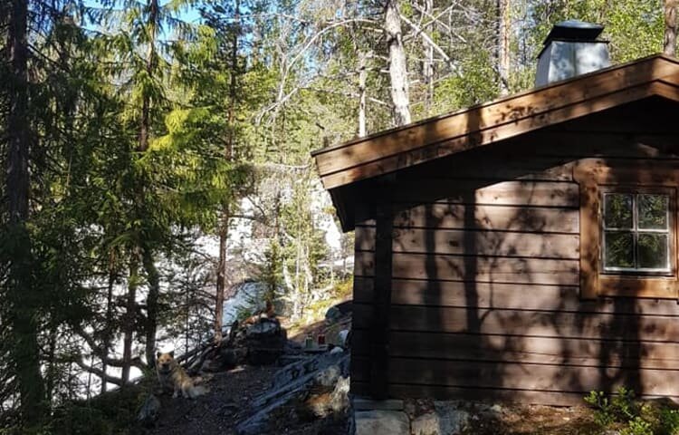
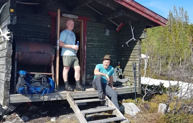
Raststuga för övernattning vid Rändåfallet -

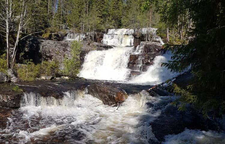
Rändåfallet -

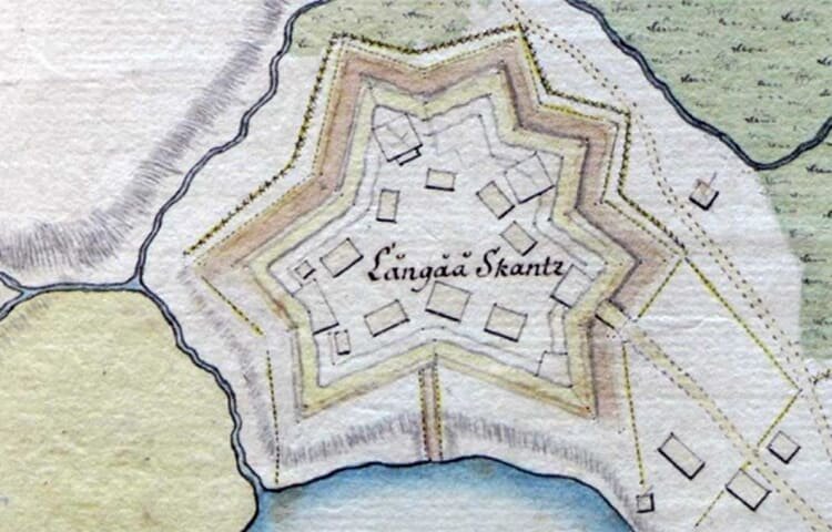
Långå skans -

Norgesvilden rastplats
Foto: Albin Lärnefjord -

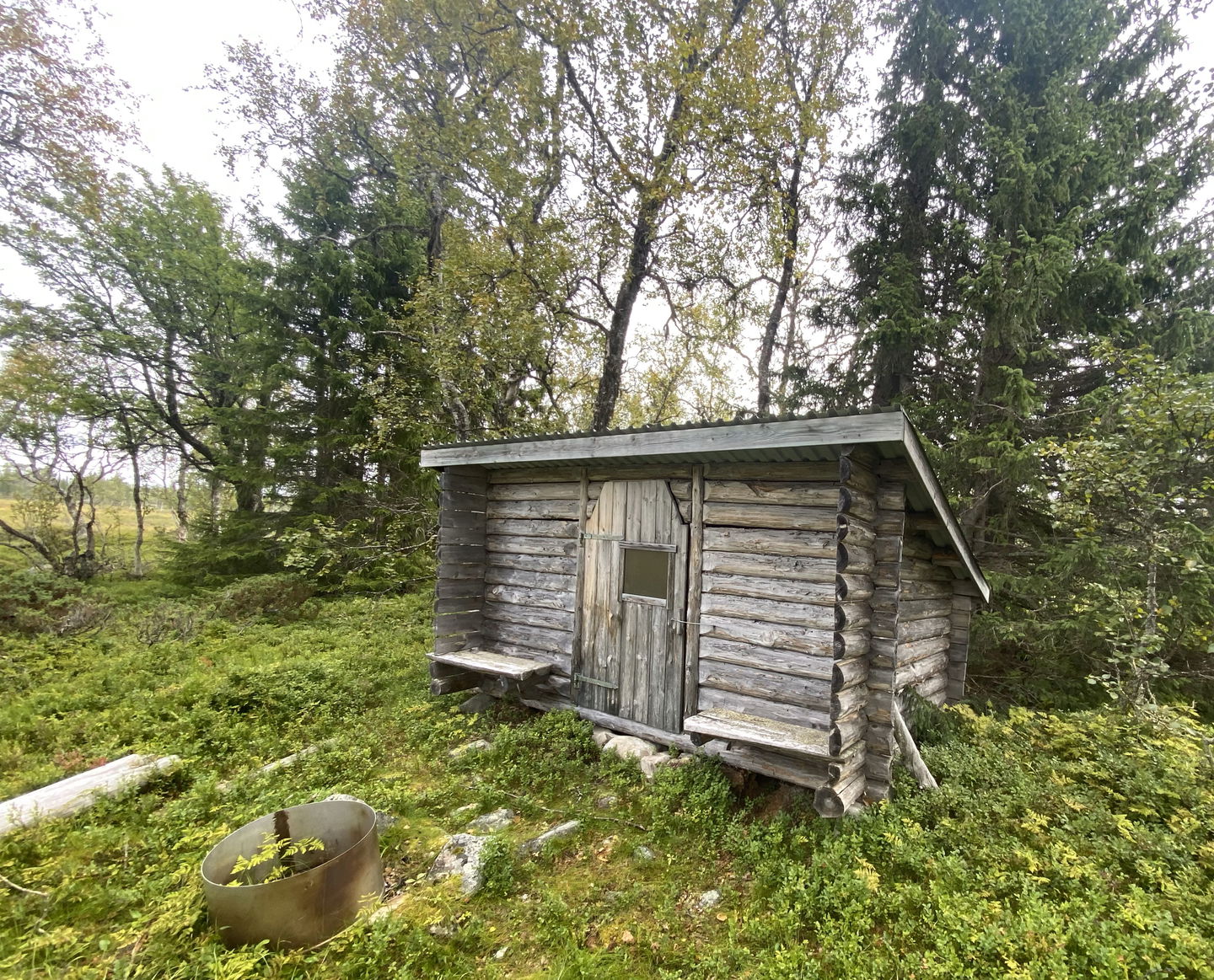
Lillfjällsstugan -

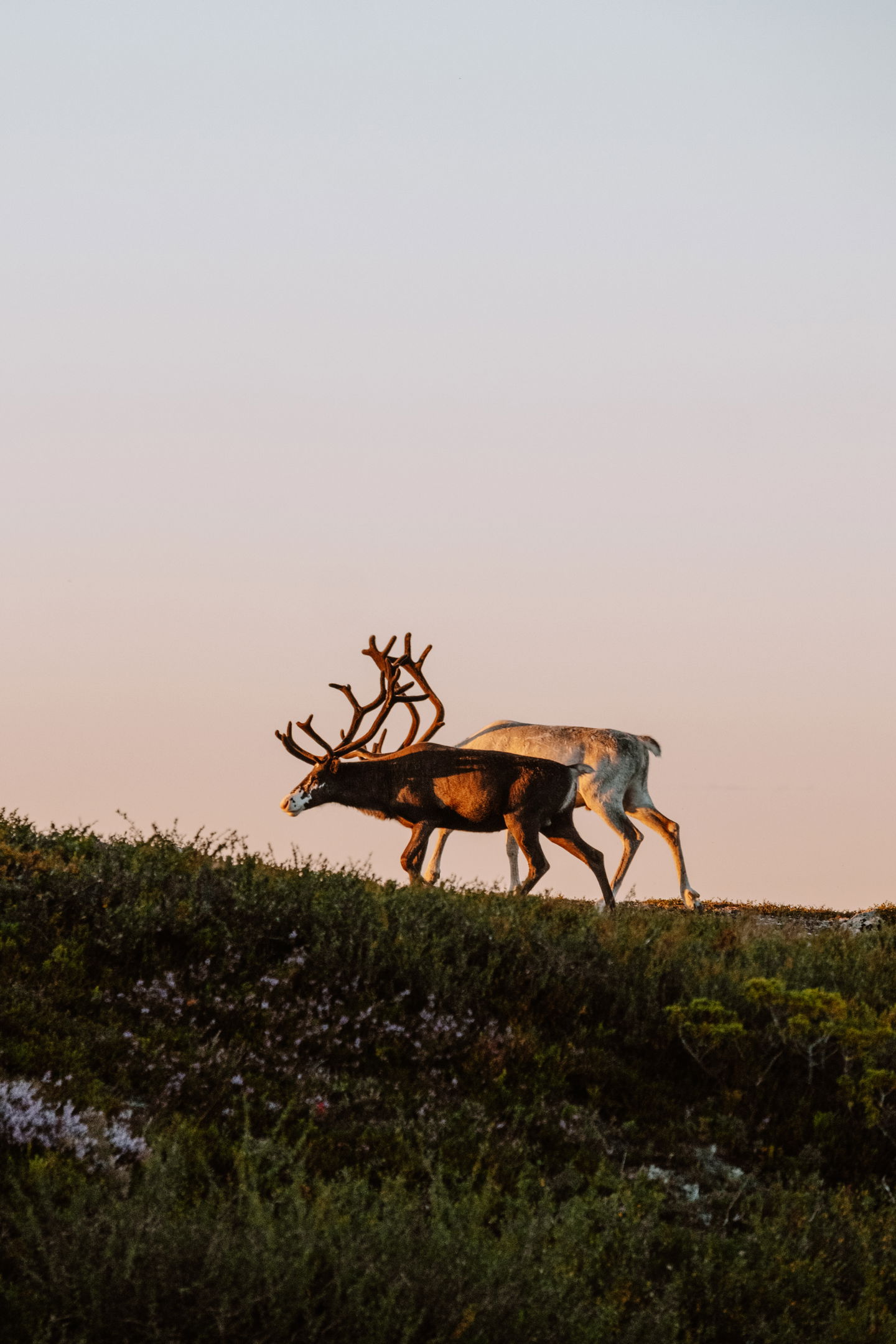
Renar på fjället
Foto: Sara Gärdegård -

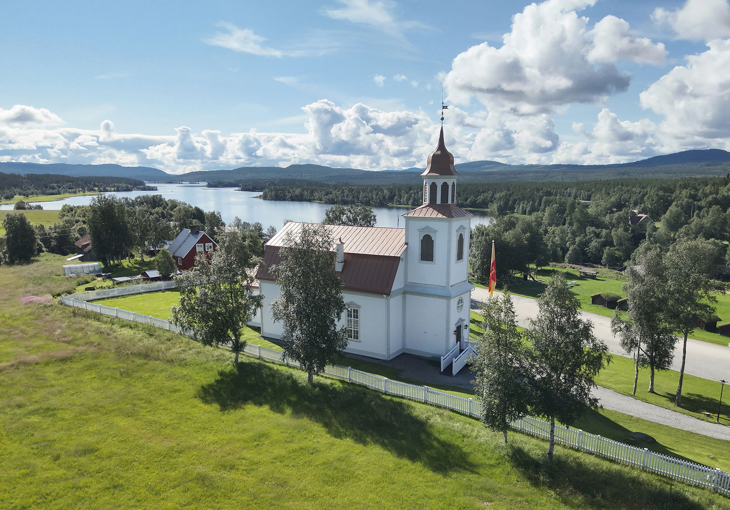
Ljusnedal kyrka

Rändåfallet -Lillfjället - Ljusnedal, Romboleden Etapp 28
Pilgrim Trail
- Landkreis: Jämtlands län
- 6408.4 km von Ihnen entfernt
Details zum Weg
- Länge 35.0 km
- Zeit 35 Std.
- Schwierigkeit Schwarz - erfahren
Aktionen
Aktuell
This stage requires mountain experience and is recommended for hiking in July, August, September.
The stage goes over high mountain areas and in forest close to the mountains with rapid changes in the weather. Sometimes there is no path to follow.
Map and compass are necessary as well as the knowledge to use them in the terrain. You should also have the Naturkartan app available offline on your mobile.
Running water is found in the mountain nature, water purification systems and tents are recommended for safety reasons. You need to carry enough food with you for the entire stage.
The mountains are a sensitive area during the summer season, where the reindeer calves are born in April and May and the deer need grazing until August. Do not disturb and keep your distance if you see reindeer, and always keep dogs on a leash.
Beschreibung
This stage follows the rushing waters of Rändån and traverses the rocky slopes of Lillfjället, offering magnificent views. On open mountains, the trail is marked by cairns.
You pass the ancient rest area Norgesvilden, and west of Lillfjället, a medieval signpost and altar. These landmarks testify that you are walking the same route as medieval pilgrims. Near Ol-Jonsvallen, you have a choice of two routes. Take the historic trail directly to the Bruksvallarna arena, or the trail that passes Ljusnedal and Funäsdalen.
The stage is demanding, lacks any services, and includes multiple fords and wet bogs. Bring a map, compass, extra food, and plan for two overnight stays.
Read more about the stage
The stage starts from Rändåfallet's parking lot. From there, the trail has long since been marked, on posts, trees and with cairns up in the mountain area. The paint is worn and it is necessary to be able to "read the nature" to find your way. It adds an additional historical dimension. It gives a feeling of following a path where people have walked for centuries.
Following the river Rändan's swirling and cascading water in smaller and larger waterfalls is an experience. Feel free to stop and enjoy Rändåfallet's rest house before taking the gravel road to help you get up the mountain. After Stensmolet and a beautiful mountain forest, you come to the marshes. There, it's time to aim for the rest cabin Lillfjällstugan, which is fantastically situated up on the mountain with a view that stretches for miles. Here you can sleep and just enjoy for a while. There is usually firewood in the wood shed. Feel free to leave a penny to Hede Snow mobile club, which has arranged the service in Lillfjällsstugan. The descent to Lillfjällsstugan is about 15 kilometers.
From Lillfjällsstugan follows a magnificent hike over the mountain Lillfjället. If the weather is bad, you should stay in the cabin until it gets better. Up in the mountain, it is easier to see the red-painted rocks but if is foggy outside its impossible. When you come down from the mountain, it can be a little more difficult to see the markings in the forest.
When you pass the height between Backvallsuggen and Gråvålen, the path is well visible and well used. Eventually you reach the snowmobile trail, it is then better to cross the river Tevån and walk on the minor road north of the river and towards Ol-Jonsvallen.
In Ol-Jonsvallen, you can choose to walk the former medieval route directly to Bruksvallarna's chapel, which today is an alternative route.
This stage continues towards Ljusnedal's church and is the recommended route after Ol-Jonsvallen as it is safer and more beautiful to follow. It is not historically accurate, but it takes you past the churches and Härjedalen's Fjällmuseum as well as the Ancient Park, which guide you about the medieval history of Western Härjedalen in different ways. In addition, there is everything you need from shops, restaurants, hotels and doctors in Funäsdalen. Feel free to take an extra rest day in Funäsdalen and take the opportunity to rent a bicycle to visit Hedningsgärdet, a historic site with remains from the 18th century. There is an altar that is used for outdoor worship services in the summer.
Historic route
During the 1990s, Tage Persson from Härjedalen's fornminnesförening participated and marked this stage. He says that they looked for ancient road markings. The stones could be almost completely overgrown with moss. They dug them up and they were positioned so that they showed the direction in which direction the path would continue next.
Walk in the footsteps of the pilgrims
Romboleden (Rombo Way) is a pilgrimage route that people began using in the 11th century. The Romboleden is Sweden’s longest pilgrimage route at 900 kilometres long. It starts in Köping in Västmanland and finishes in Trondheim on the Norwegian Atlantic coast. If you walk the entire trail, you will experience a beautiful and varied landscape. You will walk on old chalet paths, over mountains with magnificent vistas and along narrow country gravel roads. You will find easy one-day walks with cafés along the way, and long treks that take several days. The route often passes through small villages.
Ähnliche Veranstaltungen
Aktivitäten und Einrichtungen
-
 Wandern
-
Pilgrim Trail
Fakten
An overnight rest cabin is available at Rändåfallet, approximately 1 kilometer from Rändåfallet's parking lot.
Rest area Norgesvilden, approximately 12 kilometers from Rändåfallet's parking lot.
A rest cabin for overnight stay is situated on the eastern side of Lillfjället, about 15 kilometers from Rändåfallet. There is firewood here for campfires. Feel free to give a penny to Hede Snow mobile club, which has arranged the service in Lillfjällsstugan.
It is recommended to bring a tent for overnight stays along the stage.
Drinking water is found in rivers and streams, you are responsible for purifying your water yourself.
Do not count on mobile phone coverage on the stage.
Oberfläche
No paths in the high mountain area, forest and gravel road and unpaved terrain.
Hügel
Hilly mountain terrain.
Parking
Parking is available at Rändåfallet's car park and Ljusnedal's church, as well as in Långå.
Kommunikation
Public transport Härjedalingen and Länstrafiken Jämtland.
Härjedalingen serves nearby Långå and Funäsdalen, directly from Stockholm and Uppsala.
Train from Stockholm to Östersund or Ljusdal and further by bus to Funäsdalsfjällen and Ljusnedal.
You can get to Funäsdalsfjällen by car, bus, plane, or train with transfer. Most people drive to get here, but it's also great to go by bus. The nearest airport is in Röros in Norway, as well as airports in Sveg and Östersund, with transfer options to Funäsdalsfjällen.
Please note that advance booking of bus/taxi may be required.
Anleitung
The nearest bus station at the start of the stage is Saxvall, 1 minute's walk to Rändåfallet's car park.
The nearest bus station at the end of the stage is Ljusnedal, 1 minute's walk from Ljusnedal's church.
Verordnungen
This is hiking on in high mountain areas that require more of you as a hiker and careful preparation.
As a hiker, you are responsible for finding out about any local regulations, paying attention to traffic and showing consideration for others who share the trail with you.
Whenever you visit Swedish nature you have a Right to public access. Read more about it here.
As a hiker you are sometimes walking in protected nature with specific rules and regulations. You are responsible for making sure you are following the rules. You can read more about it at the Swedish Environmental Protection Agency and the County Administrative Board.
Remember to only start camp fires in established barbecue areas and ensure that there is no fire ban in your area.
Remember that you are hiking on someone else's land and that rational agriculture or forestry may occur along the trail.
Downloads
Bitte beachten Sie, dass einige dieser Texte automatisch übersetzt worden sind.
Fragen & Antworten
Stellen Sie eine Frage an andere Naturkartan-Nutzer.
