2025-08-07--21 , Slå följe med Hali Liddell från Lillhärdal till Ramundberget på Romboleden!
07 Aug
- Stadt/Ort: Lillhärdal


Pilgrim Trail
This stage requires mountain experience and is recommended for hiking in July, August, September.
The stage goes over high mountain areas and in forest close to the mountains with rapid changes in the weather. Sometimes there is no path to follow.
Map and compass are necessary as well as the knowledge to use them in the terrain. You should also have the Naturkartan app available offline on your mobile.
Running water is found in the mountain nature, water purification systems and tents are recommended for safety reasons. You need to carry enough food with you for the entire stage.
The mountains are a sensitive area during the summer season, where the reindeer calves are born in April and May and the deer need grazing until August. Do not disturb and keep your distance if you see reindeer, and always keep dogs on a leash.
Here, you walk across open mountain terrain – with panoramic views of the mountain ranges – and through forested areas. The stage is marked with Romboleden trail markers as well as red markings.
You move through old regions with traces of medieval pilgrimages. On Rishöjden, north of Lofsdalen, the original path is still visible, worn down by centuries of hooves and footsteps. At "Hälsingestenen," a pilgrim is said to have lost their life, and Bokån is believed to have been named after a priest who dropped a book into the water.
The trail runs far from settlements, over open mountains with rapidly changing weather, and across a stream that must be forded. Bring a map, compass, extra food, and plan for an overnight stay.
The stage starts at Rombovallen in Lofsdalen and ends at Rannsundet. Expect 2-3 days of mountain hiking on this stage.
Hiking starts from Rombovallen and continues north towards Fruhågna and then Rannsundet. When you pass the Strådalsvallen, there are sparse markings.
Fruhågna is said to have received its name from a pilgrim who is said to have stated; "You shouldn't just be a simple maid. You should be called Fruhågna". Probably in honor of the Virgin Mary. Legend has it that it was a pilgrim who gave birth to her child at Fruhågna. She must have asked Maria for intercession in need and then thanked her for a successful delivery. (Source: Stefan Åslund, Lofsdalens kulturförening)
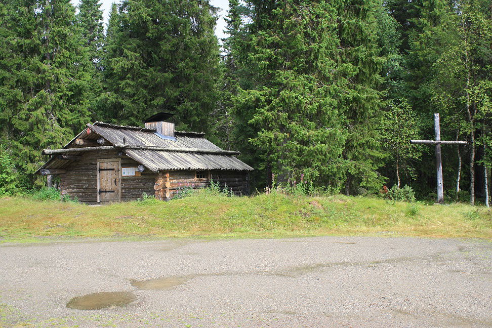
Just south of Lussifjället there is a barbecue hut in which you can sleep. There is often wood here for starting a camp fire. There is also a privy next to the hut. If you follow the trail in the direction of Fruhågna, there is a water source about 10 minutes' walk from the barbecue hut. You can also take water from one of the water pounds nearby, but make sure to purify the water properly in that case.
North of Fruhågna you come down to Bokdalen and crossing the river Bokån, which does not usually cause any major problems to cross. The path is marked but you have to pay attention in order to find the markings. Follow the eastern slopes of Kölsjöfjället further towards Kölsjön, where it is nice to rest for a while.
The part further towards Rannsundet is sometimes rough and you move close to the reindeer fence. Follow Rannsjön's shoreline to the village of Rannsundet.
Romboleden (Rombo Way) is a pilgrimage route that people began using in the 11th century. The Romboleden is Sweden’s longest pilgrimage route at 900 kilometres long. It starts in Köping in Västmanland and finishes in Trondheim on the Norwegian Atlantic coast. If you walk the entire trail, you will experience a beautiful and varied landscape. You will walk on old chalet paths, over mountains with magnificent vistas and along narrow country gravel roads. You will find easy one-day walks with cafés along the way, and long treks that take several days. The route often passes through small villages.
07 Aug
 Wandern
Pilgrim Trail
Wandern
Pilgrim Trail
Overnight in Lofsdalen with camping, cabins, hotels as well as grocery stores and restaurants.
The Själastugan (small cottage) at Rombovallen offers the option of staying the night.
Grillkåta (small hut with open fire) at Fruhågna (Lussifjäll) where you can spend the night. There is privy here and there is usually firewood by the barbecue pit.
Cottages to rent via the web in Rannsundet and Långå.
Expect mobile coverage to be lacking along the stage.
Paths or sometimes no paths in mountain forest and on bare mountains as well as some gravel roads.
Hilly mountain terrain.
Parking available at Lofsdalen, Rannsundet and Långå.
Public transport Härjedalingen and Länstrafiken Jämtland
Bus services Lofsdalen.
Taxi are available in Lofsdalen.
The nearest bus station for the stage start is Lofsdalen, 1 hour's walk from Rombovallen.
There is no public transport from the end of the stage in Rannsundet.
This is hiking on in high mountain areas that require more of you as a hiker and careful preparation.
As a hiker, you are responsible for finding out about any local regulations, paying attention to traffic and showing consideration for others who share the trail with you.
Whenever you visit Swedish nature you have a Right to public access. Read more about it here.
As a hiker you are sometimes walking in protected nature with specific rules and regulations. You are responsible for making sure you are following the rules. You can read more about it at the Swedish Environmental Protection Agency and the County Administrative Board.
Remember to only start camp fires in established barbecue areas and ensure that there is no fire ban in your area.
Remember that you are hiking on someone else's land and that rational agriculture or forestry may occur along the trail.
Bitte beachten Sie, dass einige dieser Texte automatisch übersetzt worden sind.
Stellen Sie eine Frage an andere Naturkartan-Nutzer.
Artikel i DN idag 30 oktober 2019 om Helige Olov, pilgrimsvandring på Romboleden och inte…
